| |
Fella river area, Friula Venezia Giulia |
| |
The Friuli-Venezia-Giulia region lies in north-eastern Italy, bordering with Austria and Slovenia. It extends from the Carnian and Julian Alps in the north, through the prealpine hills and the Friulian plain, to the Adriatic Sea, making it a diverse region with various kinds of topographic and climatic patterns. Our case study area is situated between the Carnian and Julian Alps in the discharge area of the river Fella, which is a major left-hand tributary of the Tagliamento river. The area is characterized by steep slopes and high precipitation levels; in the higher altitude areas the annual precipitation can reach up to 3000 mm and frequent extreme daily rainfall exceeding 500 mm have been recorded in the area in 20-30 years time span. The Fella river catchment has a mean altitude of 1140 m a.s.l and an average mean precipitation of 1920 mm (Sangati 2009). As rainfall is concentrated mainly in intense and erosive showers, it determines the torrential regime of the rivers in the area. The area is also seismically active and characterised
by a dense distribution of landslides.
The Fella river is a part of the Tagliamento river system, which is the dominant river system in the Friuli-Venezia-Giulia region.
The case study area has complex physical-geographic characteristics defined by steep slopes and a dense river network, posing serious limitations for human activities. Extreme precipitation events leading to hydro-meteorological hazards such as flash floods and landslides are frequent and have caused casualties as well as damage to infrastructure worth in tens of millions of Euros. Although it is a rural area in depopulation, the recent trends suggest that future development (expansion of touristic and recreational areas) could result in further increase of hydrometeorological risks. Increase of exposed elements at risk due to urbanization could aggravate the consequences of expected climate changes. It is interesting for research due to its complex socio-economic background demonstrated in the alpine settlement and land use pattern.
|
| |
 |
| Presentations |
Presentation by Civil Protection part 1: The 2003 event |
| |
Presentation by Civil Protection part 2: Investigations |
| |
Presentation by Civil Protection part 3: Remedial works |
| |
Presentation by Civil Protection part 4: Mapping |
| |
Presentation by Civil Protection part 5: General information |
| Fieldvisits |
Field report October 2012 |
| |
Field report December 2011 |
| |
List of data requirements |
| |
Summary of interventions |
| |
References |
| Stakeholder meetings |
Report stakeholder meetings in April 2012 |
| |
Report stakeholder meeting in April 2013
|
| |
Workshop for the Evaluation of First Level Inspections: Support tool for the management of check dams
September 22-23/2014
|
| |
Final stakeholder meeting on November 20 2014
- Agenda
- Flyer
|
| Data access |
http://horatius.irpi.pd.cnr.it/changes/ |
| |
|
| REsults |
Results for the Fella area
Work has been carried out by a number of ESRs on the Fella area. Part of this work was done in combination with the INCREO project. for the Fella area the following maps were produced:
Also work has been done on aspects related to:
- Land use change scenarios;
- Comparing risk governance strategies;
- Use of risk information in spatial planning;
- role of community knowledge and participation for hydraulic-structure inspections;
- Collaborative decision making in selection of risk management strategies
A dissemination workshop with the stakeholders in the Fella area is planned for 20 November 2014. |
| |
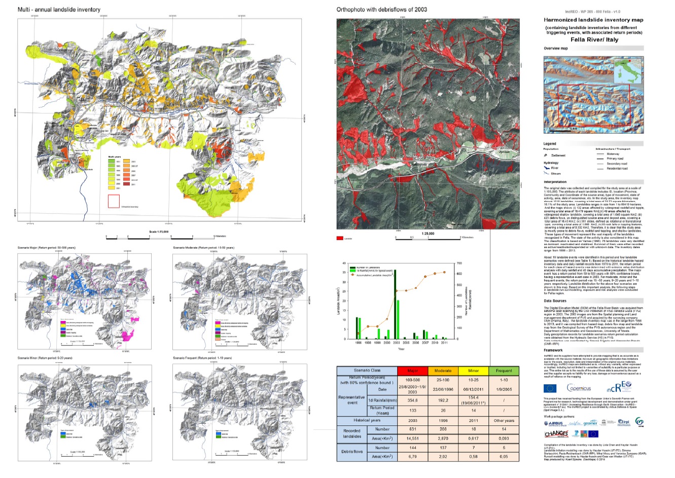 Landslide inventory map Landslide inventory map |
| |
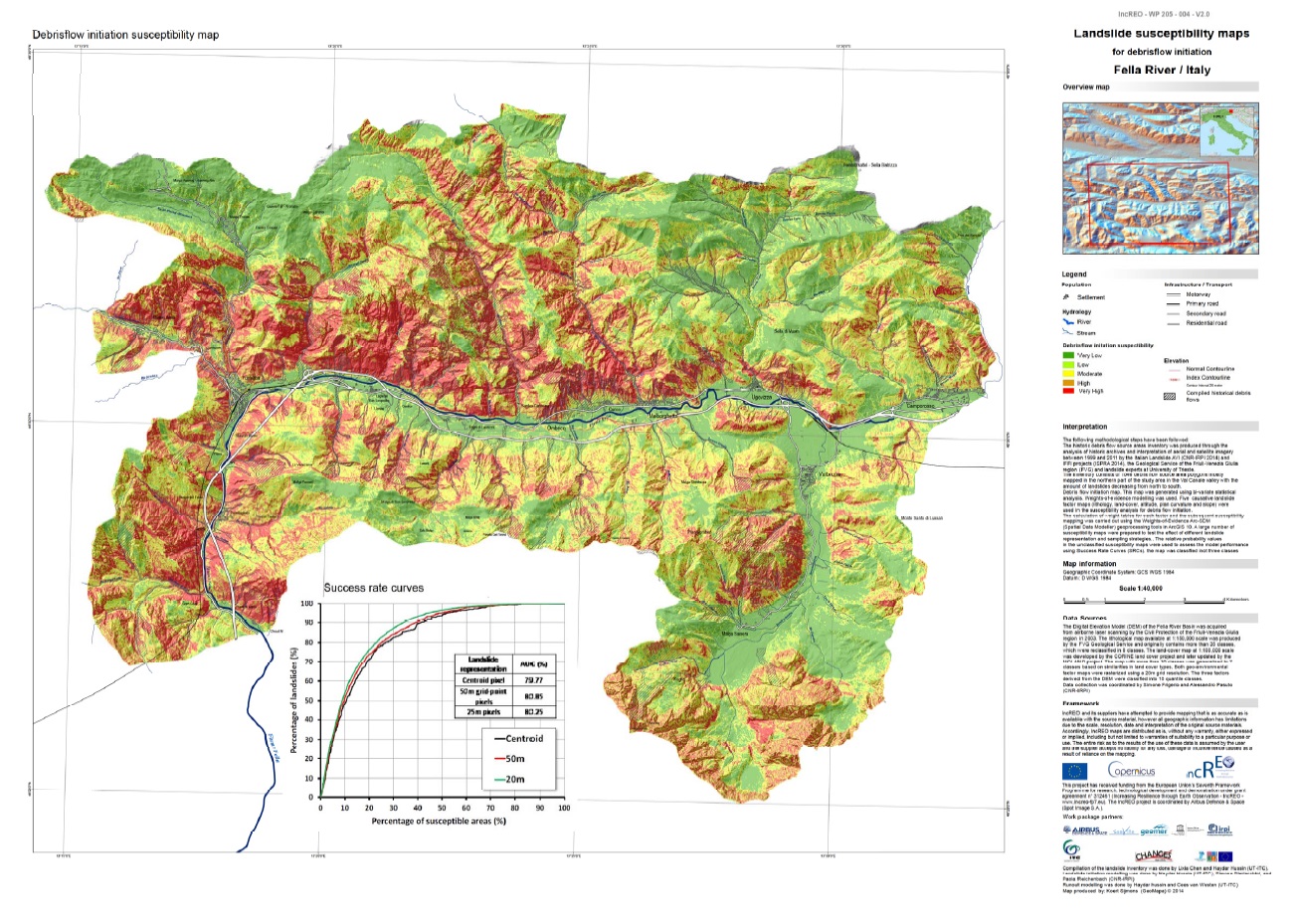 Debris flow initiation map Debris flow initiation map |
| |
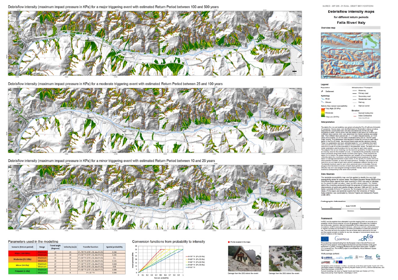 Debris flow runout hazard map Debris flow runout hazard map |
| |
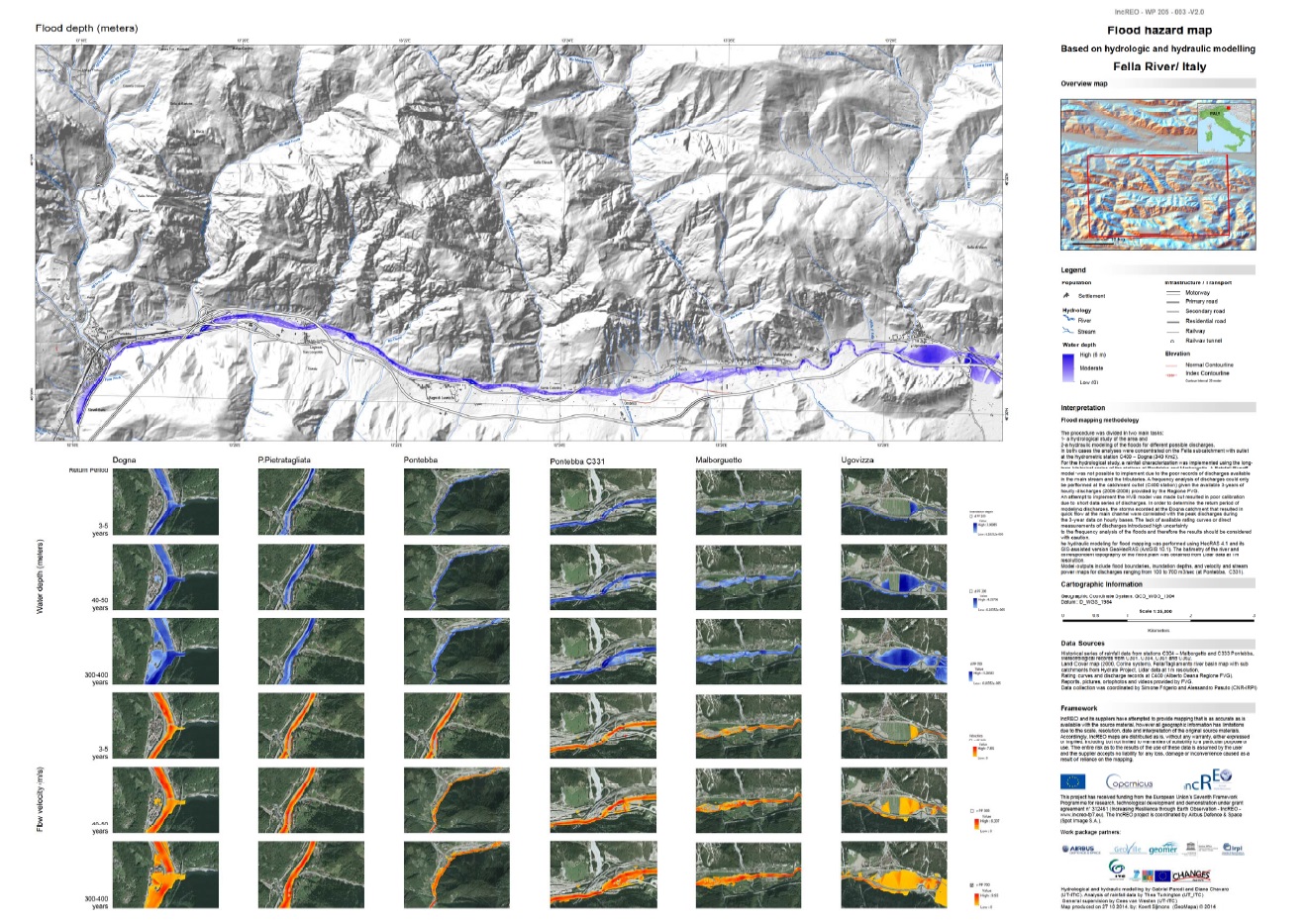 River flood hazard map River flood hazard map |
| |
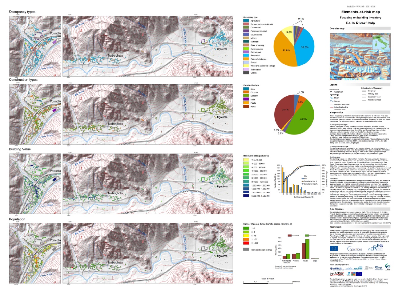 Building map Building map |
| |
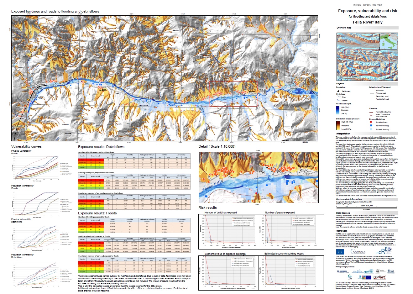 Exposure, vulnerability and risk map Exposure, vulnerability and risk map |